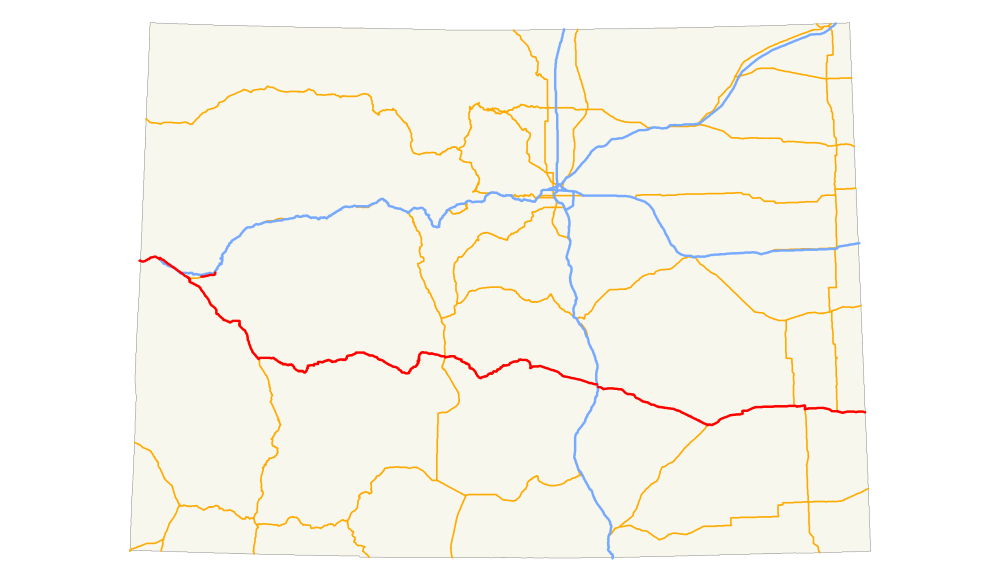
In the U.S. state of Colorado, U.S. Route 50 is a major highway crossing through the lower midsection of the state. It connects the Western Slope with the lower Front Range and the Arkansas Valley. The highway serves the areas of Pueblo and Grand Junction as well as many other smaller areas along its corridor. The long term project to upgrade the highway from two lanes to a four lane expressway between Grand Junction and Montrose was completed in January 2005. Only about 25% of the remainder of highway 50 in Colorado is four lane expressway.
Route description
Western Slope
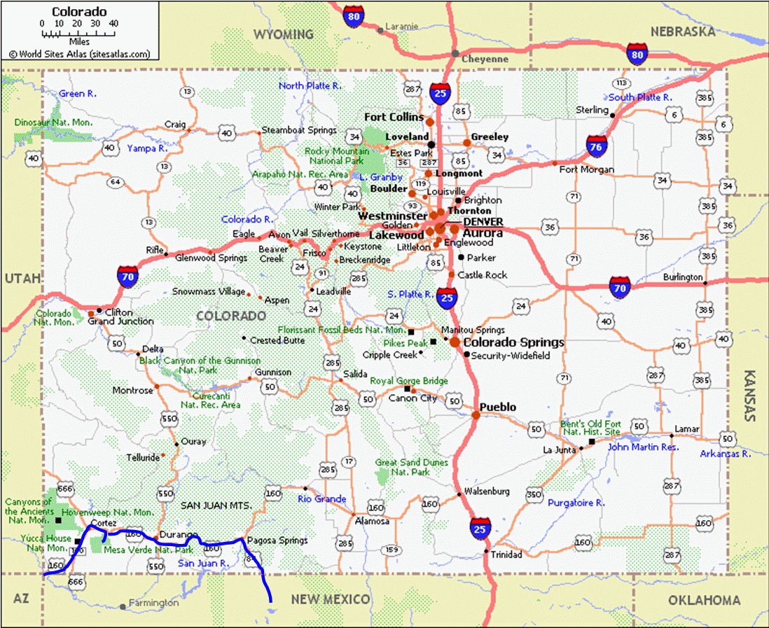
U.S. Route 50 begins in Colorado at the Utah state line, concurrent with Interstate 70 as well as U.S. Route 6. At Interstate 70 exit 11, U.S. Route 6 & 50 end their concurrency with Interstate 70 and begin using the old highway alignment directly north of Interstate 70 while they travel through the communities of Mack, Loma, and Fruita. These communities were bypassed by Interstate 70. Near mile marker 15 the Colorado River adjoins Interstate 70 and runs nearby for the next 16 miles (26 km). In Fruita routes 6 and 50 intersect Colorado State Highway 340, the gateway to the Colorado National Monument. The monument's sandstone canyons and rock spires are visible to the south from the highways.
U.S. Route 6 & 50 meet again with Interstate 70 at exit 26 where they begin a concurrent segment with Interstate 70 Business Loop. The three routes travel southeast towards downtown Grand Junction. Grand Junction is the home of Colorado Mesa University. U.S. Route 6 ends it concurrency with U.S. Route 50 and Interstate 70 Business loop with a free flowing, grade separated interchange at North Avenue. The two remaining routes continue south onto surface streets in downtown Grand Junction. At Grand Avenue, they once again intersect with Colorado 340, which forms a loop between Grand Junction and Fruita. There are several points of access to the Colorado National Monument from the highway 340 loop.
After turning onto two east-west one way streets (Ute and Pitkin Avenues); U.S. Route 50 detaches itself from Interstate 70 Business Loop, crosses the Colorado River and travels as an expressway, though suburban Grand Junction, to the cities of Delta and Montrose. Leaving Grand Junction and the area known as Orchard Mesa, the highway descends into the community of Whitewater and the Gunnison River valley. It intersects with Colorado State Highway 141 and begins a short concurrency with highway 141. Near this intersection Mount Sneffels (14,158 feet (4,315 m)) and the Sneffels Range of the San Juan Mountains are clearly visible 80 miles (130 km) miles to the south-southeast.
As it follows the Gunnison River valley in a southeasterly direction, it is bounded on the east by Grand Mesa, which rises to over 11,000 feet (3,400 m) and on the west by the Uncompahgre Plateau, averaging 9,500 feet (2,900 m) and rising to 10,300 feet (3,100 m). U.S. Route 50 travels through Delta as a typical surface street, having junctions with Colorado State Highway 92 and Colorado State Highway 348. Then highway 50 heads towards Montrose in the Uncompahgre River valley, passing through Olathe as an expressway bypass. Olathe is the home of a popular annual sweet corn festival. Agriculture in the area is greatly enhanced by irrigation water supplied by reservoirs on the Gunnison River. U.S 50 arrives in Montrose on Townsend Ave. The route then junctions with U.S. Route 550 and turns east onto the San Juan Avenue bypass and then onto Main St. heading eastward out of Montrose.
The highway is a four-lane expressway from the Utah border to the eastern boundary of Montrose except for surface streets in the towns of Grand Junction, Delta and Montrose. From Montrose east to the Kansas border it is primarily a two-lane highway with only short stretches of four-lane highway. The upgrade of the last segment of highway between Utah and Montrose was completed in January 2005. The first 94 miles (151 km) of route 50 is four-lane highway. Of the remaining 375 miles (604 km), only about 90 miles (140 km) had been upgraded to four lanes as of 2012, primarily around larger towns.
About ten miles east of Montrose, the highway intersects Colorado State Highway 347. This 5.2 miles (8.4 km) long highway provides access to the Black Canyon of the Gunnison National Park. Highway 50 then passes over Cerro Summit, about 8,000 feet (2,400 m), descends to the small community of Cimarron on the Cimarron River and ascends again to the Blue Mesa Summit, 8,850 feet (2,700 m) before dropping into Blue Creek Canyon. 3 miles (4.8 km) north of the stream crossing, where Blue Creek empties into the Gunnison River, is the Curecanti Needle, a striking rock formation that is the symbol of the now defunct Denver & Rio Grande Western Railroad. The needle is now accessible only by boat since the abandoned railroad line was flooded by Morrow Point Lake, formed by the completion of the Crystal Dam in 1976. U.S. Route 50 rises again over a third low pass before reaching Colorado State Highway 92. A short distance north of the intersection, highway 92 crosses the Blue Mesa Dam which forms Blue Mesa Reservoir, the largest body of water in the state of Colorado. Highway 50 crosses the reservoir at Middle Bridge, intersects Colorado State Highway 149 near the east end of the reservoir and continues into the town of Gunnison, home of Western State College of Colorado.
East of Gunnison the highway intersects with Colorado State Highway 114, passes through the communities of Parlin and Sargents and then ascends to Monarch Pass (elevation 11,312 feet (3,448 m)) on the continental divide. Monarch Pass is the highest point on the entire length of U.S. 50.
Arkansas River Valley
After descending from Monarch Pass, the highway enters the Arkansas River Valley near the town of Salida. The headwaters of the Arkansas are about 50 miles (80 km) north near Leadville. The Arkansas is the second-longest tributary to the Missippi-Missouri River system. U.S. 50 closely follows the Arkansas River from Salida to Kansas. East of Salida the highway enters a deep canyon of the Arkansas River. There are several small communities in the canyon including Howard, Coaldale and Cotopaxi. The major industries in the canyon are fishing and river rafting.
Near mile marker 267 the highway crosses the river and leaves the canyon. A short distance later, County Road 3a leads to the rim of the Royal Gorge and its famous suspension bridge. The Royal Gorge Bridge is 1,260 feet (380 m) long and 956 feet (291 m) above the Arkansas River. It was built in 1929 and remains a popular tourist attraction.
After Royal Gorge highway 50 passes through Cañon City. Fremont County, which includes Cañon City, is the home to 15 prisons, including ADX Supermax, the only federal Supermax prison in the United States.
U.S. 50 intersects Colorado State Highway 67, Colorado State Highway 115 and Colorado State Highway 45 before arriving at Interstate 25 in Pueblo, the home of the annual Colorado State Fair. Pueblo is at the edge of the Rocky Mountains, the beginning of the plains of southeastern Colorado. As the highway heads east across the plains, it generally follows the path of the Arkansas River until it reaches Kansas. Along the route it passes through a number of small communities including Rocky Ford, La Junta and Lamar.
Just beyond La Junta the highway passes Bent's Old Fort National Historic Site where travelers can find information about life on the plains.
Between Pueblo and Kansas highway 50 intersects with a number of state highways and U.S. highways. The U.S. highways are U.S. Route 350, 287, 385 and 400. It runs concurrently with 287 and 385 for short distances and with 400 from Granada, Colorado to Dodge City, Kansas, a distance of 136 miles (219 km).
U.S. route 50 in Colorado ends at the Kansas state line, about 4 miles (6.4 km) east of Holly, Colorado, 467.6 miles (752.5 km) from the Utah border. Holly has the lowest elevation of any town in Colorado at 3,392 feet (1,034 m).